
Getting stir-crazy? Take your stroller and enjoy a nature walk through Calgary with your baby or toddler!
Calgary’s topography, with the river valleys, ravines, and coulees throughout the city, make for some wonderful wilderness walks that lead to stunning views. Enjoy these wild urban walkabouts!
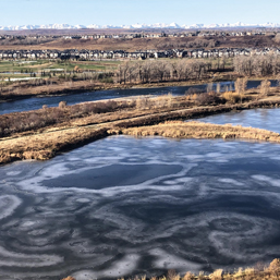
Walk 1: Cranston & Rotary Nature Park in Fish Creek Provincial Park
From the paved pathway along the Cranston escarpment the views are far-reaching. On a blue-sky day in March, the Rockies, crisp and white on the horizon, call out to you to grab your skis or snowshoes and come play in the snow. Follow the paved pathway and descend into the Rotary Nature Park wetlands. At one time a gravel pit, the area was reclaimed into its natural state and became part of Fish Creek Provincial Park. The area hosts 40 acres of wetlands that attract waterfowl and upland birds, making this park the perfect sanctuary for birdwatching.
As you walk, you can ponder the changes to the landscape that have happened here over time. Glaciers covered Fish Creek Provincial Park in 13000 BCE. The glaciers retreated over time, and humans are believed to have first settled in small numbers in the Fish Creek Valley around 6500 BCE. More than 80 archaeological sites have been identified throughout the park. The University of Calgary archaeological team has uncovered evidence of early buffalo hunts, weapons, First Nations campsites, cooking utensils, and other ancient artifacts. At least four locations in the park have been identified as buffalo jumps and kill sites used by hunters between 2500 BCE and 1700 CE. The oldest identifiable artifact found in the park to date is a broken atlatl head, dated around 2500 BCE.
Continue along the paved pathway and along the Bow River north for a longer walk, or loop around the wetland and climb the escarpment on the single-track trails towards Stoney Trail. Once at the top of the escarpment, walk south to connect to the paved pathway and return from whence you came.
Starting point: Street parking along Cranridge Heights, SE.
Tasty pitstop: Good Earth Coffeehouse, 356 Cranston Road SE or Lina’s Italian Supermercato, 4916 130 Avenue SE.
Walk 2: Twelve Mile Coulee, NW
Wild walkabouts tucked into suburban neighborhoods are always a pleasant surprise. Tuscany’s Twelve-Mile Coulee Park got its name in the early days because it is approximately 12 miles (19 km) from Fort Calgary and was a convenient mileage marker on the stagecoach run from the Fort Calgary main post office to the mission church at Morleyville, a missionary outpost. The Métis used the term coulée, which means “small valley” or “gully,” to describe the type of landscape in the park. It comes from the French verb couler, meaning “to flow,” which is appropriate since the spring snow-melt leads to a rise in creek water level.
The route begins on high ground and descends into the treed coulee where a few trail options make for a varied walk. You can walk above the creek, on the slope-side trail, or along the coulee bottom. Adventurous creek hoppers will enjoy using their creative navigating skills since the trail diverges in many areas and, depending on how much water is in the creek, you may have to backtrack and choose a higher route. This is the kind of exploring that kids love!
Those who choose to stay high and dry will walk through shrubs of willows, red-osier dogwoods, and American silverberry, as well as stands of trembling aspen, balsam poplar, and white spruce while on the north-facing slopes. The south-facing slopes are drier and host native prairie plants: rough fescue, Perry oat grass, and spear grasses thrive here. If you’re a rockhound, check out the large, bedrock, sandstone outcroppings at the south end of the park. This is Calgary’s best and most accessible example of the Porcupine Hills Formation that underlies the entire city. Walk to the end of the coulee, near Nose Hill Drive, and begin the long gradual climb to the community of Tuscany and to views of the Rocky Mountains, Canada Olympic Park, and the downtown core. Continue along the paved path at the top of the coulee or pick a trail and descend back into the wilderness. Creek-hop back to your starting point.
Starting point: Park in the official parking lot off Tuscany Boulevard, just north of Scenic Acres Link.
C-Train: Tuscany station and a short walk
Tasty treat: Bring your own treat and have a picnic!
Walk 3: Stanley Park, Roxboro Natural Park, The Wandering Island & Evamy Ridge Park, SW
Walk from Stanley Park uphill to Parkhill, a neighborhood with unique architecture. Skirt the escarpment above the Elbow River Pathway, following grass paths while soaking up big views of the Rockies beyond and eventually, the community of East Elbow Park below. Stick to the single-track trail that circles around the Southern Alberta Pioneer’s Building and watch for Bald Eagles soaring at eye’s view along the Elbow River before leaving the green space and walking east along to 34 Avenue to 2 Street.
Enjoy downtown views as you walk north on 2 Street and connect to the hidden stairway to Mission Road. Once across Mission Road take the treed path uphill into Roxboro Natural Park. Enjoy spectacular downtown views as you follow the trail north along the top of the escarpment and then downhill into the trees to the Roxboro off leash park. Continue west along Roxboro Road to 4 Street where you take a few steps north to access the entrance to The Wandering Island (wanderingisland.ca), off Mission Bridge. In late 2020 this collaborative art park opened with a mandate to create “slow art for the audience of birds, bats, beaver, fish, and the occasional curious wanderer.”
Ideal for little ones, the single-track trail skirts the periphery and ends in the perfect picnic spot. There’s lots of seating along the trail and ample opportunity for kids to explore some urban nature, throw a few rocks and perhaps see a beaver! Once off the Island, you can backtrack south to Rideau Road, turn right, and continue to the Elbow River Pathway that leads back to Stanley Park or keep walking into Cliff Bungalow. Walk north on 5 Street and turn left onto 23 Avenue to connect to the stairway that leads you to stunning downtown views as you climb up the escarpment to Mount Royal and Evamy Ridge Park. A gift from CP Rail in 1920, this little park with big views was created in 2021. Kids on your walk may want to detour to the playground at the Montessori School before embarking on the climb. Post climb, continue to Earl Grey Crescent and walk around the escarpment to the stairs that lead to the Glencoe Club. Take the stairs down and connect to Elbow Drive and the pedestrian bridge across the Elbow River, back to Rideau Road and the Elbow River Pathway.
Starting point: Stanley Park official parking lot, 42 Avenue, just west of 1A Street, SW
C-Train: 39 Avenue station and then a short walk
Tasty pitstop: Stop at one of these 4 Street SW spots: Yann Haute Patisserie, Phil & Sebastian Coffee, Purple Perk Café.
Lori is the author of the best-selling guidebooks Calgary’s Best Walks and Calgary’s Best Bike Rides. She is the owner of Fit Frog and the CTV Morning Live segment host. She leads walks, hikes, and snowshoe days with her company Fit Frog, free library walks in partnership with the Calgary Public Library and she presents to groups on the pleasures of exploring Calgary and beyond on foot and by bike. Connect with her and get a signed copy of her books on Instagram & Facebook @lorifitfrog and at fitfrog.ca. Find her books at bookstores and cool shops throughout Calgary.
See our related articles:


Calgary’s Child Magazine © 2024 Calgary’s Child
